

An astrocartography map shows where each planet falls on the Ascendant, IC, Midheaven, and Descendant angles around the world. Each planet produces four lines. An AI astrocartography interpretation uses the map alongside birth-chart details to explain the themes associated with different locations. The map offers a symbolic framework for comparing places, not a universal answer about where to live.
It’s natural to want a clear signal when a move could reshape your work, relationships, or sense of home. How precisely the map can offer that signal depends in part on the birth data used to calculate it: a more exact birth time gives more precise planetary-line positions.
This guide explains how the four angles shape a map, how planetary lines are constructed, and what can support an AI reading. You’ll learn how to compare locations thoughtfully and how interpretation can turn a complex map into a more useful relocation framework.
Key Takeaways
- Read MC, IC, ASC, and DSC lines as distinct themes for career, home, identity, and relationships, then notice where planetary lines cluster.
- Compare a city’s distance from a line with the map’s wider geographic context; proximity can shape how strongly a line is interpreted.
- Give AI the generated map and report evidence so its interpretation can connect planetary placements to specific locations rather than rely on broad generalities.
- Use precise birth-time information when constructing a map, since time-zone history and daylight-saving changes can affect planetary-line positions.
- Explore Ask Lala AI Spiritual Guidance when you want help reflecting on what a location’s symbolism may mean for your personal choices.
What do MC, IC, ASC, and DSC lines mean?
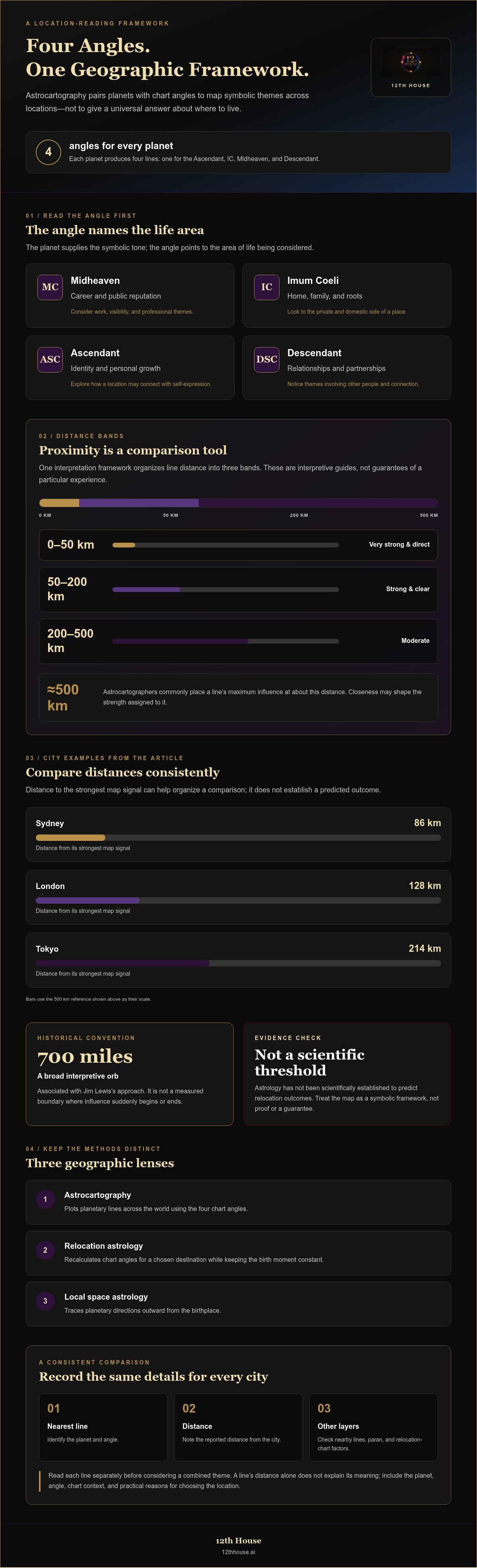
Astrocartography plots planetary lines on a world map according to four chart angles: MC, IC, ASC, and DSC. Each line pairs a planet with an angle, creating a symbolic lens for comparing how different places may emphasize aspects of life.
The angle identifies the life area; the planet supplies the symbolic tone. Midheaven (MC) lines are associated with career and public reputation, while Imum Coeli (IC) lines relate to home, family, and roots. Ascendant (ASC) lines concern identity and personal growth. Descendant (DSC) lines focus on relationships and partnerships. For example, compare the planet on an MC line with the work and visibility themes you’re considering.
Distance adds a geographic layer. Astrocartographers commonly place a line’s maximum influence at about 500 km (310 miles), with closeness shaping the strength assigned to it. One interpretation framework describes locations 0-50 km (0-30 mi) from a line as very strong and direct, 50-200 km (30-125 mi) as strong and clear, and 200-500 km (125-310 mi) as moderate. Treat these bands as a way to organize comparisons, not as a guarantee of a specific experience.
When planetary lines run close together, the area is sometimes treated as a coupling zone, where multiple planetary and angular themes appear within the same geographic region. Read each line separately before considering their combined symbolism. A Venus line near an MC line, for example, still requires identifying which planet belongs to which angle. Paran lines add another layer, marking places where planetary angles meet geographically; they differ from the map’s standard angle lines. Local space lines instead extend outward from the birth location in planetary directions.
Astrocartography compares planetary lines across the world. Relocation astrology examines how a natal chart’s angles shift for a chosen destination, while local space astrology traces planetary directions from the birthplace. These methods can complement one another, but each uses a different geographic framework.
To cross-check a city, first identify the planet and angle shown on its nearest line. Then compare that pairing with the natal chart and the report’s interpretation. A line’s distance alone doesn’t explain its meaning. Read challenging planetary lines as symbolic themes to examine, not predictions of harm. Consider the planet, angle, chart context, and practical reasons for choosing that location.
When comparing cities for a move, use the same steps for each: note the nearest planetary line, its angle, and the reported distance. Then record whether nearby lines or a paran add another layer. This keeps the map’s influence in context and makes comparisons more consistent.
The Astrocartography 700-Mile Orb: Myth or Reality?
The 700-mile orb is a historical interpretive convention, not a measured boundary. Astrocartography is an astrological practice; scientific evidence has not established that planetary lines predict relocation outcomes.
Maps and Geographic Locations
An astrocartography map places planetary lines over geographic locations, letting you compare cities against your birth chart. The 700-mile influence claim originated with Jim Lewis, who created astrocartography in the 1970s. It describes a broad interpretive range, not a precise border where a line suddenly begins or ends.
Consider the map’s strongest nearby signal alongside the actual distance. In one city comparison, London is 128 km from its strongest map signal, Sydney is 86 km away, and Tokyo is 214 km away. Those measurements help organize a comparison; they don’t establish a predicted outcome or prove a uniform influence.
Relocation Chart Analysis
A relocation chart recalculates the chart for a chosen destination while keeping the birth moment constant. Its angles shift with location, offering another way to examine the same move. Compare the relocation chart with the astrocartography map: one highlights a place-specific chart structure, while the other plots planetary lines across geography.
For a move to Tokyo, for example, note the relevant signal on the map, then examine Tokyo’s relocated chart. Keep the birth chart as your reference point. This layered approach helps separate natal themes from the way a destination changes angular emphasis.
Distance rules remain interpretive. The 700-mile figure is associated with Jim Lewis’s approach, but a broad orb can make distant locations seem equally relevant. Compare nearby cities using the same method, and record the planetary line, location, and chart factors behind each reading. Avoid treating the orb as a guarantee or a scientific threshold.
Comparing two people requires separate birth charts and maps. Choose the same candidate cities for both, then identify each person’s nearby lines and relocated chart angles. A place that emphasizes career themes for one person may highlight home or relationship themes for the other. Compare those distinct patterns before considering shared priorities.
Use this sequence to keep a relocation comparison grounded: select candidate cities, identify each city’s map signals, then inspect its relocation chart. For two people, repeat the steps with both charts. An AI astrocartography interpretation can organize supplied map and report details, but the result remains an astrological interpretation, not scientific proof.
For a more structured comparison of birth-chart themes and location, explore a birth-chart and astrocartography reading.
AI interpretation using generated map and report evidence
An AI reading is most useful when its claims can be traced to a generated map and report. Treat those materials as evidence to interpret, not decoration. For each city, connect the named planetary line and angle with the report’s stated theme. This makes the reasoning easier to inspect and correct.
Start with the inputs: the birth date, birthplace, and birth time used to generate the map. An exact birth time helps place planetary lines more precisely, while historical time-zone or daylight-saving errors can shift a chart. If an app supplies calculations, check whether it identifies its astronomical ephemeris and states that its data is up to date.
Give the AI a focused task rather than asking it to choose your future. Compare 3-4 places, as a practical reading approach recommends, and provide matching map and report details for each. Ask it to:
- Identify the planetary line and angle associated with each city.
- Summarize the report’s interpretation of that planet and angle.
- Compare shared themes and meaningful differences across the cities.
- Separate visible map details from interpretive conclusions.
For example, if a report links a city to a Venus line, ask the AI to name the angle shown on the map. Then ask how that angle changes the emphasis. A Venus-MC pairing and a Venus-IC pairing shouldn’t be treated as interchangeable. The map provides the location signal; the report supplies interpretive context.
Generated city reports can organize comparisons, but their conclusions should remain tied to their inputs. Ask which map feature supports each statement, and request a distinction between reported details and inference. If a city summary describes career themes without naming its line or angle, ask how the two connect. This turns a broad reading into a traceable explanation.
Follow-up questions can refine the comparison. Ask how a second nearby line might change one city’s interpretation, or what differs when comparing its map with another city’s report. Keep each prompt specific. A focused question about one location produces a clearer analysis than asking an AI to rank every city worldwide.
An AI astrocartography interpretation can help structure symbolic evidence, but it cannot make an astrological reading scientific proof. Use the generated map and report to inspect the calculation trail, clarify assumptions, and compare locations with your actual priorities. If the map and written report conflict, identify the mismatch before relying on the summary.
Astrocartography’s definition, purpose, history, and origins
Astrocartography maps a birth chart’s planetary positions onto a world map. Its purpose is to explore how locations correspond with astrological themes, not to rank cities through a universal formula. Jim Lewis created astrocartography in the 1970s, giving this mapping approach its modern form. The map turns chart calculations into a geographic framework for considering relocation.
To understand the method in context, separate the calculation from the symbolism. Birth details establish the chart; geographic coordinates show where planets align with angular positions. Each planet produces four lines, corresponding to the Ascendant, IC, Midheaven, and Descendant. The resulting map connects a symbolic chart structure with places on Earth, but interpretation still depends on the astrologer’s framework.
Jim Lewis also originated the claim that planetary lines have a 700-mile influence. That figure belongs to an astrological interpretive tradition, rather than a scientific measurement of an effect. Its practical purpose is to give readers a broad area for comparing locations near a line. Keep that historical claim distinct from the underlying map calculation and from any personal conclusion.
Accuracy begins with the birth information used in the calculation. A precise birth time gives more precise planetary-line positions, while historical time-zone and daylight-saving errors can shift a chart. Enter the time as precisely as possible, ideally to the minute; half-hour precision is described as sufficient. For example, both the recorded local time and its historical time-zone context affect the chart’s starting coordinates.
Calculation tools also matter. An ephemeris provides planetary-position data used in chart work; Swiss Ephemeris is one named example readers may encounter. Check whether an app identifies its astronomical ephemeris and states that its data is up to date. These details clarify the calculation basis, but they don’t validate astrology’s symbolic meanings or establish scientific evidence for relocation outcomes.
Use the map as a structured comparison tool. Select a destination, identify the planetary line and angle, then interpret that pairing alongside the birth chart. A city near a Moon-IC line, for example, is read through lunar symbolism and the IC’s home themes. The location supplies context; the chart supplies the symbolic language for interpretation.
The method’s history also explains why its maps shouldn’t be mistaken for ordinary geographic forecasts. Jim Lewis’s 1970s system organizes astrological placements by location, while a map’s precision depends on accurate birth-time and time-zone inputs. Separate the calculated line placement from the meaning assigned to it. That distinction keeps technical accuracy and symbolic interpretation clear.
For a practical reading, record the birth data, the map’s calculation details, and the destination you want to examine. Then compare the map with its written interpretation. This sequence shows what the chart calculates and where interpretation begins, keeping astrocartography’s history, method, and purpose in context.
Construction and interpretation of astrocartography maps
An astrocartography chart needs your birth date, birthplace, and birth time. The time should be as precise as possible, ideally to the minute; half-hour precision is described as sufficient. These details establish the birth chart used to calculate where planetary lines meet geographic angles.
Each planet produces four lines, corresponding to the Ascendant, IC, Midheaven, and Descendant. The calculation places those angular relationships around the world, turning a birth chart into a location map. Read a line’s planet and angle together to interpret its meaning, rather than treating every planetary line as the same signal.
Construction depends on accurate time data as well as the birth details. Historical time-zone and daylight-saving errors can shift a chart or its planetary lines. For example, a birthplace’s past clock rules may differ from its current time zone. Accurate birth-time conversion is part of the calculation, not a cosmetic detail.
Interpret the map in a fixed sequence. First, select a city you’re considering. Next, identify its nearest planetary line and angular position. Then connect that pairing with relevant birth-chart themes. If a city sits near a Jupiter-Midheaven line, for example, read Jupiter and the Midheaven together before considering what their symbolism could mean for public or career life.
Distance helps structure a comparison, but it does not supply the full meaning. Astrocartographers commonly place maximum influence at about 500 km (310 miles). One described framework calls 0-50 km (0-30 mi) very strong, 50-200 km (30-125 mi) strong, and 200-500 km (125-310 mi) moderate. Use those bands to compare locations consistently, not as fixed boundaries or outcome promises.
Keep the map’s scope clear. Astrocartography represents the birth chart across locations; it doesn’t by itself describe event timing. To explore timing, distinguish current planetary movements from the natal map. Tie relationship, work, and home themes to the chart’s actual planetary and angular placements, not to a city name alone.
For a disciplined comparison, record each candidate city, its closest line, the angle, and the distance shown. Then compare those notes with the chart report and your relocation priorities. Focus on 3-4 places at a time, so each interpretation has clear evidence and context. This method makes calculations easier to inspect and helps separate map details from symbolic conclusions.
Build your location comparison with Astrocartography Mapping when you want a chart-based framework for examining places.
12Th House: Ask Lala AI Spiritual Guidance
12th House’s Ask Lala AI Spiritual Guidance offers a next step when you want to reflect on what a location’s symbolism brings up for your decisions. Use it to explore your questions and organize your thinking, rather than treating a map as a command to move.
If you want to consider location themes alongside your natal chart, Astrology Birth Chart & Transit Analysis can add birth-chart and transit context. Tarot Readings and Numerology Reports offer other reflective frameworks when they better fit the question you’re exploring.
Bring a specific city or life decision into your reflection, then consider how the interpretation relates to your practical priorities. Contact 12th House to explore the guidance that fits your question.
Turn Your Map Into a Thoughtful Next Step
A relocation decision deserves more than a compelling symbol. Let your map open a focused inquiry: what do you want your next place to support, and what practical conditions must also be true? An AI astrocartography interpretation can help organize your reflections, but your priorities give the comparison its purpose.
Choose a city and write down the question that matters most. Is it about belonging, meaningful work, or the kind of relationships you hope to cultivate? Ask Lala AI Spiritual Guidance can help you explore that question. Astrology Birth Chart & Transit Analysis offers another way to consider your chart, while Tarot Readings can support reflection when you’re weighing a choice.
Use the symbolism as a prompt for discernment, not a substitute for your own judgment. Let insight sharpen the questions you bring to a real-world move, then decide with care and intention.
Contact 12th House for an interpretation and take the next step in your exploration.
Frequently Asked Questions
What is astrocartography?
Astrocartography is an astrological mapping method that places birth-chart planetary positions on a world map. Readers use it to reflect on how different places may correspond with themes in their chart. For example, someone weighing a move might compare a city’s nearby line with the areas of life they want to explore, then consider practical factors such as work, community, and daily needs.
What is astrocartography and how does it work?
Astrocartography translates a natal chart into geographic lines associated with planets and chart angles. The calculation uses birth details to map where planets align with angular positions around the world. An interpretation connects a location’s planetary and angle pairings with astrological symbolism. For instance, compare a prospective city’s map with its written report, and note which details come from the chart and which are interpretation.
How do you calculate and read astrocartography lines?
To calculate a map, use the birth date, birthplace, and most precise birth time available. The calculation plots each planet’s angular lines geographically; an AI astrocartography interpretation can help organize the resulting details. To read a candidate city, identify its nearby line, note the planet and angle, then compare those symbols with the report. Check the birth-time and time-zone inputs if a map seems inconsistent.
What do the Sun, Moon, and planetary lines mean in astrocartography?
Planetary lines represent symbolic themes associated with each planet and its chart angle. In astrological interpretation, a Sun line is often read through visibility, vitality, and self-expression; a Moon line through emotional needs, familiarity, and care. The angle shapes the context for those themes, such as public life or home. Read the full planet-angle pairing rather than assigning one fixed meaning to every line.
What do the Ascendant, Descendant, Midheaven, and IC angles mean?
The angles indicate different life contexts for interpreting a planetary line. Ascendant themes concern identity and personal growth; Descendant themes involve close relationships and partnerships. Midheaven themes relate to career and public reputation, while IC themes connect with home, family, and roots. For example, compare the same planet on an IC line and a Midheaven line, then note how the angle changes the question you’re asking.
How close to an astrocartography line do its effects apply?
Astrocartographers commonly place a line’s maximum influence at about 500 km (310 miles), but distance is interpreted as a gradient, not a sharp boundary. One framework describes 0-50 km (0-30 mi) as very strong, 50-200 km (30-125 mi) as strong, and 200-500 km (125-310 mi) as moderate. Use these bands to compare locations consistently, not to predict a guaranteed experience.
How do you compare multiple planetary lines near a location?
Read each nearby line as its own planet-angle pairing before combining themes. Write down the line, angle, and distance for the location, then consult the map’s report for each interpretation. If a city lies near a Venus line and a Saturn line, for example, don’t collapse them into one label. Consider what each pairing contributes, and compare the reading with your reasons for considering the city.
What are the best astrocartography lines for career, relationships, and home life?
There isn’t one best line for everyone; the relevant pairing depends on your goal and chart. For career questions, examine Midheaven lines and the planet involved. For relationships, compare Descendant lines; for home life, look at IC lines. A Venus pairing may be interpreted differently from a Saturn pairing, so compare the planetary symbolism with your priorities instead of choosing by angle alone.


